Connect with 4Sight to explore how our underground LiDAR capability can strengthen your subsurface data and keep your project on track.

Incomplete information about what exists below grade is one of the most avoidable risks on any infrastructure project. 4Sight's Light Detection and Ranging (LiDAR) chamber scanning service is built to fill that gap with precision.
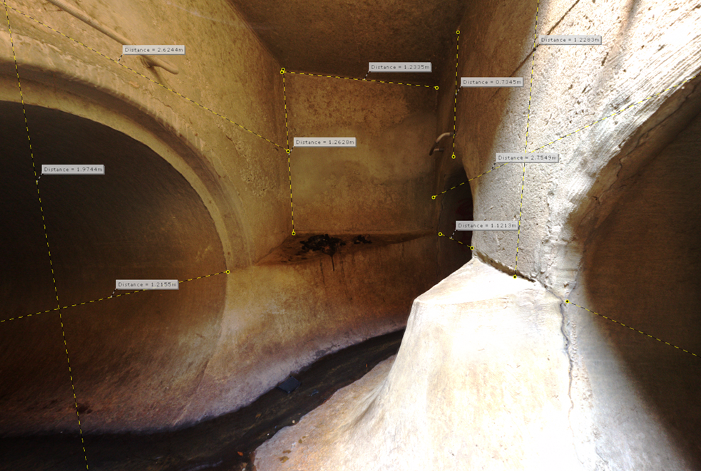
Chamber scanning is more than lowering a camera into a manhole. It starts with a site assessment to understand what is expected below grade, moves through precise below-ground scanning to capture the full geometry of the space, and concludes with a detailed 3D point cloud that integrates directly into design and asset management workflows. Every scan is carried out using a disciplined, structured approach, so the data you receive is accurate, complete, and ready to use.
Using an inverse-mounted tripod, we place the scanner up to 5m below grade to achieve direct line-of-sight within confined underground spaces. The scanner captures data across a range of up to 70m, with accuracy to 2mm at 10m and 3.5mm at 25m. Where 4Sight is genuinely unique is in how we have refined this process specifically for underground utility infrastructure and chamber environments, and in our ability to merge below-ground scans with surface LiDAR data to produce a seamless, fully integrated 3D model of your entire utility environment.
Why Partner With 4Sight
Choosing the right LiDAR scanning partner can significantly influence what your team knows, how confidently decisions get made, and how smoothly a project moves through design and construction. 4Sight stands out because we combine purpose-built underground scanning capability with deep subsurface expertise and a project-first approach.
What Sets 4Sight Apart
1. Specialized Underground Capability
Our chamber scanning approach has been developed and refined specifically for below-grade utility environments, not adapted from general survey practice.
2. Integrated Above and Below Ground Modelling
We combine chamber scans with surface LiDAR data to produce a seamless, fully integrated 3D model of your utility environment, providing your team with a complete picture.
3. No Confined Space Entry Required
The scanner collects data below grade while technicians remains safely above ground, eliminating confined space permits and the safety exposure that comes with them.
4. Unlimited Post-Visit Measurements
Point clouds are delivered as RCP files compatible with AutoCAD or viewable in Scene LT, integrated directly into your existing design workflow with no additional processing required.
5. Integrated SUE Approach
LiDAR data does not exist in isolation at 4Sight. Findings feed directly into the broader Subsurface Utility Engineering (SUE) process, coordinated with survey teams, designers, and project stakeholders to close knowledge gaps and reduce risk.
6. Experienced Team, Consistent Results
Our technicians bring the same structured, quality-focused approach to LiDAR scanning that defines every 4Sight service, ensuring the data you receive supports your schedule, design process, and stakeholders.
Ready to find out more?
")
Contact
P: 1 (289) 385-3303
E: info@4SightUE.com
Address
Headquarters
4Sight Head Office
2100 Forbes Street, Unit 1
Whitby, ON
L1N 9T3
126 Market Street
Commercial Unit #1
Philadelphia,
PA 19106
© 2026 All Rights Reserved | Contact Us | Accessibility | Privacy Policy | Terms of Use
